A good hiking app does three jobs: it helps you choose a walk, it shows you where you are when the path splits in the cloud, and it keeps working when the phone signal gives up halfway up the valley. Very few apps do all three equally well, which is why so many walkers carry two.
We compared six hiking apps for walkers in Britain and abroad, from Ordnance Survey’s own mapping to American backcountry tools and a free offline map. Prices are taken from the official stores and websites. This guide is based on each maker’s official documentation, store listings and owner reviews, and we say where a claim comes from the maker.
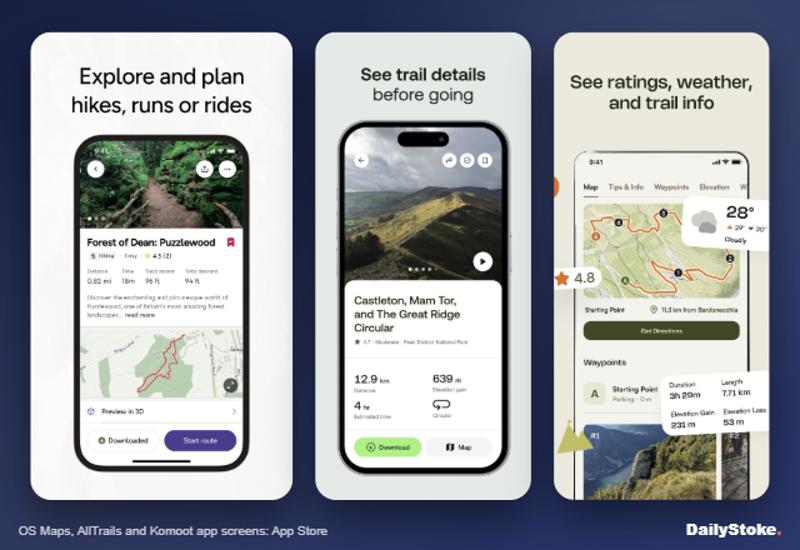
Hiking apps at a glance
| Rank | App | Price (UK) | Best for | Standout fact |
|---|---|---|---|---|
| 1 | OS Maps | Free; Premium £35.99 a year | Britain’s hills and rights of way | Explorer 1:25,000 and Landranger 1:50,000 maps for all of Great Britain |
| 2 | AllTrails | Free; AllTrails+ £35.99 a year | Finding a well-reviewed walk fast | About 500,000 routes with recent reviews |
| 3 | Komoot | Free region; World Pack £29.99 once; Premium £59.99 a year | Planning your own routes | A one-off map purchase rather than a subscription |
| 4 | Outdooractive | Free; Pro £26.99, Pro+ £53.99 | Walkers who cross between Britain and the Alps | Ordnance Survey maps for Pro members |
| 5 | Gaia GPS | Free; Premium $59.90 a year (US App Store) | Backcountry trips in North America | 300+ map layers including slope angle |
| 6 | Organic Maps | Free | A no-cost offline map with footpaths | No adverts, no account, no data collected |
How we chose these walking apps
We started with the apps British walkers actually use and the ones readers ask about, then judged each one on map quality for the hills, offline use, route finding, safety features, watch support and price. DailyStoke has reviewed AllTrails, Komoot and Organic Maps in depth, and OS Maps and Gaia GPS get full reviews in this batch.
Prices come from the UK App Store or the maker’s own site in October 2026; we could not confirm a sterling price for Gaia GPS, so we quote its US App Store figure. Ratings come from the stores. This is not a hands-on test: the guide is based on official documentation, store listings and owner reviews, and for accuracy and reliability we also draw on mountain rescue reports and specialist magazines such as The Great Outdoors. No app replaces a paper map, a compass and the skill to use them.
The best hiking apps, ranked
1. OS Maps
If you walk in Britain, Ordnance Survey’s own app is the one to beat. Premium unlocks the Explorer (1:25,000) and Landranger (1:50,000) maps for the whole of Great Britain on phone, tablet and computer, the same mapping printed on the orange and pink sheets in your car’s door pocket. Field boundaries, rights of way, access land and crags are all there, which no global app matches.
The free version shows OS standard, aerial and night maps while you have a signal and lets you plot routes, but offline maps and GPX export need Premium. Subscribers can save areas for offline use, view 3D maps and search more than 1.7 million routes. There is an Apple Watch app with topo maps and route following, and Ordnance Survey’s plan comparison also lists topographic maps for the USA, New Zealand and Australia.
Read our full OS Maps review.
Price: free; Premium £35.99 a year or £7.49 a month (UK App Store).
Pros
- The definitive 1:25,000 mapping for Great Britain
- Offline areas and GPX export on Premium
- Apple Watch app with route following
Cons
- Free version is thin and online only
- Route library quality varies, like any user-fed catalogue
2. AllTrails
AllTrails is the quickest way to find a decent walk somewhere you do not know. Search a town or national park and it returns walks with distance, climb, photos and a stream of recent reviews, which often tell you about a flooded path or a broken stile before you leave the car. It has more than 100 million members and about 500,000 routes worldwide.
The free app searches, follows and records routes while you have signal. AllTrails+ adds offline maps, wrong-turn alerts and live share; Peak adds custom routing, a community heatmap and other extras. In 2023 Keswick Mountain Rescue Team was called to walkers stranded on steep scree after following an AllTrails route on Barf Fell, so in the British hills treat it as a finder and check routes against an OS map.
Read our full AllTrails review.
Price: free; AllTrails+ £35.99 a year; Peak £79.99 a year.
Pros
- Huge, well-reviewed route library
- Wrong-turn alerts and offline maps on AllTrails+
- Sends routes to Garmin and COROS watches
Cons
- No offline maps on the free plan
- Some user-added routes are poorly checked
3. Komoot
Komoot is the planner’s app. Its routing engine is good at threading quiet lanes, bridleways and footpaths between two points, and it shows the surface and the climb before you commit. It is just as strong for cyclists, which is why households that walk and ride often settle on it.
New users get one free region for navigation. After that you can buy maps outright, including a World Pack at £29.99 that covers everywhere, or subscribe to Premium at £59.99 a year for multi-day planning, live tracking for family and 3D maps. The one-off option is the rare chance in this category to pay once rather than every year. Komoot has been owned by Bending Spoons since March 2025.
Read our full Komoot review.
Price: one free region; World Pack £29.99 once; Premium £59.99 a year.
Pros
- Excellent route planner for walking and cycling
- One-off map purchase option
- Strong syncing with Garmin and other devices
Cons
- Base map lacks the detail of OS mapping in the hills
- Premium is the priciest plan here
4. Outdooractive
Outdooractive, made by Outdooractive AG in Germany, is the app we would pick for someone who walks in the Peak District in spring and the Dolomites in summer. Its route library leans on tourist boards, national parks and publishers rather than only on users, and it carries official topographic maps from 25 countries.
For British walkers the key detail is in the UK App Store listing: Ordnance Survey maps are available to Pro members. Pro, at £26.99, also adds offline maps and tours, satellite view and an advert-free app. Pro+, at £53.99, brings 3D previews and premium map sets, including Alpine Club maps and, according to Harvey Maps, Harvey’s Superwalker and British Mountain Map data for the UK and Ireland. There is an Apple Watch app and a BuddyBeacon for sharing your live position.
Price: free; Pro £26.99; Pro+ £53.99 (UK App Store).
Pros
- OS mapping for Pro members at a lower price than many rivals
- Official maps across much of Europe
- Curated routes from tourist boards and publishers
Cons
- Busy interface with many menus
- Some map sets only on the dearer Pro+ tier
5. Gaia GPS
Gaia GPS is the serious backcountry navigator, popular with American backpackers, hunters and overlanders. Its strength is layers: Premium unlocks more than 300 maps and overlays, from National Geographic Trails Illustrated sheets to slope-angle shading for avalanche terrain, plus France’s IGN and Switzerland’s SwissTopo maps. It supports Apple Watch and CarPlay.
For Britain it is a weaker choice. Gaia does not offer current Ordnance Survey 1:25,000 maps, a gap users have raised in its own community forum for years. Its Gaia Topo map, built on open data, is fine for many routes but lacks rights-of-way detail. The free tier records trips and shows Gaia Topo, but offline downloads need Premium.
Read our full Gaia GPS review.
Price: free; Premium $59.90 a year or €59.90 (US and German App Stores). UK buyers pay the sterling price the App Store or Google Play shows at checkout.
Pros
- Huge map catalogue with slope-angle and public-land layers
- Strong offline downloads and trip recording
- Apple Watch and CarPlay support
Cons
- No current OS 1:25,000 mapping
- Price rose sharply in 2024, according to long-time users
6. Organic Maps
Organic Maps is a free, open-source offline map built on OpenStreetMap, made by a small team in Estonia. Download a country before you travel and every feature works without signal: search, turn-by-turn walking directions, hiking paths, contour lines and elevation profiles. There are no adverts, no account and, according to its App Store privacy label, no data collected.
It is not a route library and it will not replace OS mapping in the hills, but as a free backup that runs offline on any phone it is hard to fault. It is also the best option here for city breaks that end with a walk in the hills.
Read our full Organic Maps review.
Price: free; donations optional.
Pros
- Completely free and offline
- No ads, no tracking, no registration
- Contour lines and hiking paths
Cons
- No curated walks or reviews
- OpenStreetMap detail varies by area
What happened to FATMAP?
FATMAP, the 3D mapping app loved by ski tourers and mountaineers, no longer exists. Strava bought it in January 2023 and announced in June 2024 that the app and website would close on 1 October 2024, TechCrunch reported. Users could move routes to Strava before then, but only the title, description and route line transferred; grades, photos, guidebooks and waypoints did not. Strava has since added 3D maps and Flyover route previews to its own app. For ski touring with slope-angle layers, Gaia GPS is the closest like-for-like replacement here, while OS Maps and Outdooractive both offer 3D views.
Choosing a walking app: what matters and what to ignore
Map quality where you walk. In Britain, OS 1:25,000 mapping (in OS Maps or Outdooractive Pro) shows field boundaries, access land and rights of way. Abroad, check whether the app carries official national maps.
Offline maps. The most important paid feature. Download your area at home on Wi-Fi, then put the phone in aeroplane mode and test it before you leave.
Battery. GPS tracking drains phones. Carry a power bank on long days and consider a watch for navigation.
Route source. Curated routes from national parks and publishers are usually more reliable than user uploads. Read recent reviews either way.
Price structure. Annual subscriptions cluster around £27 to £60. Komoot’s one-off World Pack is the main way to avoid paying every year, and Organic Maps costs nothing.
What to ignore. Badges, challenges and social feeds will not get you down a hill in cloud. Nor will a giant route count if most of those routes are on another continent.
Hiking app FAQs
What is the best hiking app for the UK?
OS Maps, for its Ordnance Survey 1:25,000 and 1:50,000 mapping across Great Britain. Many walkers pair it with AllTrails or Komoot for finding and planning routes.
Which hiking apps work without phone signal?
All six can work offline, but most only on paid plans. Organic Maps is fully offline for free; OS Maps, AllTrails, Outdooractive and Gaia GPS need a subscription, and Komoot needs a purchased region or Premium.
Is there a free hiking app with offline maps?
Yes. Organic Maps is free with no adverts and includes hiking paths and contour lines. Komoot also gives new users one free region.
What replaced FATMAP?
FATMAP closed on 1 October 2024 after Strava bought it. Strava has added some of its 3D mapping, and Gaia GPS offers slope-angle layers for ski touring.
Do I still need a paper map and compass?
Yes. Phones fail, batteries die and screens are hard to read in rain. Mountain rescue teams consistently advise carrying a map and compass and knowing how to use them.
Which hiking app works best with Apple Watch?
OS Maps, AllTrails, Outdooractive and Gaia GPS all have Apple Watch apps. OS Maps recently added topo maps and route following to its watch app.
More on DailyStoke
OS Maps review · Gaia GPS review · Best offline map apps · Best weather apps for hiking and skiing · AllTrails review · Travel apps, reviewed