OS Maps puts the Explorer and Landranger maps that British walkers have folded on summits for generations into a phone, a tablet and a browser. The free version is a taster; Premium, at £35.99 a year, is the version that matters, with the whole of Great Britain at 1:25,000 and 1:50,000, offline areas and GPX export.
Our verdict: for anyone who walks regularly in Britain, OS Maps Premium is the most useful £36 you can spend on navigation. It does not find walks as cleverly as AllTrails or plan them as smartly as Komoot, but no other app shows British hills, field boundaries and rights of way with the same authority.
OS Maps at a glance
- Maker: Ordnance Survey, Britain’s national mapping agency, Southampton
- Platforms: iPhone, iPad, Android, web, Apple Watch (watchOS 8 or later)
- Free plan: yes; OS standard, aerial and night maps online, route plotting, GPX import
- Paid: Premium £35.99 a year or £7.49 a month (UK App Store)
- Offline use: Premium only, at 1:25,000 and 1:50,000
- Routes: more than 1.7 million to search, according to Ordnance Survey’s retail listing
- Ratings: App Store (UK) 4.7/5 from 102,000 ratings; Google Play 3.8/5 from about 36,000 ratings
What OS Maps does
OS Maps is a mapping and navigation app first and a route library second. You open it to see exactly where you are on the most detailed map of Britain available to the public, to plot a route along rights of way, and to follow that route with your position glowing on the screen.
Three moments where it earns its fee:
- Cloud drops on the Glyders and the path vanishes into boulders. Your blue dot on the 1:25,000 map, saved offline before you left Ogwen, shows which side of the ridge you are on.
- You plan a circular walk in the Cotswolds and want to stay on public footpaths. The green dashed lines on the Explorer layer are the legal answer, not a guess from a crowd-sourced map.
- You want to print a strip map for a friend who will not carry a phone. OS Maps prints your route on the map you choose.
OS Maps price: free versus Premium
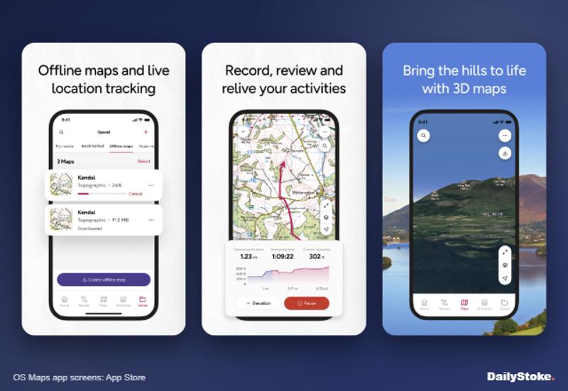
The free app, after registration, gives you OS standard mapping, aerial and night maps while you are online, route plotting and GPX import. You can follow a route, but there are no offline maps, so in a valley with no signal the screen may go blank.
Premium adds, according to Ordnance Survey:
- OS Explorer 1:25,000 and Landranger 1:50,000 mapping for all of Great Britain
- Offline saved areas at both scales
- GPX export to watches and GPS units
- 3D maps and fly-throughs
- Printing of maps and routes
Ordnance Survey’s free versus Premium comparison also lists topographic maps for the USA, New Zealand and Australia.
| Plan | UK price | US$ equivalent | € equivalent |
|---|---|---|---|
| Free | Free | Free | Free |
| Premium, 12 months | £35.99 | $47.96 | €42.71 |
| Premium, 1 month | £7.49 | $9.98 | €8.89 |
Dollar and euro figures are straight conversions for comparison. On the Irish App Store, Premium is €28.99 a year or €5.49 a month.
The cheapest way in. Look for a membership discount before paying full price. Cycling UK members get 30% off the first year, which brings it to £25.19, an offer listed until 31 March 2027. Ordnance Survey also gives mountain rescue volunteers free Premium through their teams, and runs occasional half-price sales on annual plans. If you have bought a recent paper OS map, the code inside unlocks that sheet’s area for offline use in the app.
What we liked
The map itself. This is the reason to buy. Contours at 5 or 10 metre intervals, crags, walls, access land shading and every right of way, consistent from Cornwall to Caithness.
Offline areas that work. Draw a box over your walk, save it at 1:25,000, and it stays on the phone. The Great Outdoors magazine, in its own review, praised offline downloads of 1:25,000 mapping for the whole of the UK.
Apple Watch. Version 5.6.1 added topo maps and route following on the watch, so you can glance at your wrist rather than unlock a wet phone.
Locate Me. The Great Outdoors highlighted this safety function, which shows your GPS position and a compass without phone signal, handy for giving a grid reference to mountain rescue.
Fair pricing. At £35.99 a year it matches AllTrails+ and undercuts Komoot Premium, and discounts through clubs are common.
What we did not like
The free version is thin. Without Premium there is no 1:25,000 mapping and nothing offline, so the free app is really a trial.
Route quality varies. The 1.7 million routes include many from users and partners. Some are excellent; some cut corners. Check every route against the map, which at least is easy here.
Occasional instability with big downloads. The Great Outdoors reported that saving too many offline areas could make the app crash, though it said recent updates had improved reliability.
Pricing is hard to pin down. Ordnance Survey’s own pages do not show the price until you reach checkout, and app store listings in different countries quote different figures.
Britain only, for the detail that matters. Abroad you will want another app.
How OS Maps compares
| OS Maps | AllTrails | Komoot | Outdooractive | |
|---|---|---|---|---|
| Paid from | £35.99 a year | £35.99 a year (AllTrails+) | £29.99 once (World Pack) | £26.99 (Pro) |
| OS 1:25,000 mapping | Yes | No | No | Yes, for Pro members |
| Best for | British hills and rights of way | Finding reviewed walks | Planning routes | Britain and the Alps |
| Offline | Premium | Paid plans | Purchased maps or Premium | Pro |
OS Maps vs AllTrails. AllTrails is the better walk finder, with reviews that tell you what the path is like this week. OS Maps is the better map. Many walkers use both: AllTrails to choose, OS Maps to navigate. Our AllTrails review has the detail.
OS Maps vs Komoot. Komoot plans routes more cleverly and suits people who also cycle, and its World Pack is a one-off payment. Its base map lacks OS detail in the hills. See our Komoot review.
OS Maps vs Outdooractive. Outdooractive offers OS maps to Pro members at a lower UK App Store price and adds official maps across much of Europe. Its interface is busier, and OS Maps’ tools are built around its own mapping.
Who should buy OS Maps
Buy Premium if you walk, run or ride off-road in Britain more than a few times a year, and especially if you go into the hills of Snowdonia, the Lakes or the Highlands. Skip it if you mostly walk abroad or stick to waymarked paths near towns, where a free app such as Organic Maps may be enough.
OS Maps FAQs
Is the OS Maps app free?
Yes, with limits. The free app shows OS standard, aerial and night maps online and lets you plot routes. Detailed 1:25,000 and 1:50,000 maps, offline areas and GPX export need Premium.
How much is OS Maps Premium?
£35.99 a year or £7.49 a month on the UK App Store. Paying monthly for a full year would cost almost £90, so the annual plan is far better value if you walk all year.
Can you use OS Maps offline?
Yes, with Premium. Save an area at 1:25,000 or 1:50,000 before you lose signal and it works without a connection.
Does OS Maps work on Apple Watch?
Yes. The watch app needs watchOS 8 or later and now includes topo maps and route following.
Is OS Maps better than AllTrails?
For finding your way in Britain, yes, because of the Ordnance Survey mapping. For finding a walk somewhere new, AllTrails’ reviews and photos are more helpful.
How do I cancel OS Maps?
Cancel where you subscribed. For app purchases, use the subscription settings in your Apple or Google Play account; the App Store listing says Premium renews automatically unless you cancel at least 24 hours before the period ends. If you subscribed through the OS Shop, Ordnance Survey says to use its subscription management page, select the cancel option and follow the prompts, after which you get an on-screen and email confirmation.
More on DailyStoke
Best hiking apps compared · Best weather apps for hiking and skiing · AllTrails review · Komoot review · Travel apps, reviewed