Gaia GPS is the app many American backpackers trust when the trail runs out. It is less about discovering pretty walks and more about navigation: stack a topo map, a satellite image and a slope-angle overlay, download the lot, and head into country with no signal.
Our verdict: Gaia GPS is an excellent tool for North American trips and a capable one in the Alps, thanks to IGN and SwissTopo layers. For British walkers it is a hard sell, because it does not carry current Ordnance Survey 1:25,000 mapping and costs more than OS Maps. Buy it for a Sierra or Rockies trip, or for ski touring, rather than for the Pennines.
Gaia GPS at a glance
- Owner: Outside, Inc., Boulder, Colorado (bought Gaia GPS in 2021); App Store seller Trailbehind, Inc.
- Platforms: iPhone, iPad, Android, web, Apple Watch (watchOS 7 or later), CarPlay
- Free plan: yes; trip recording, waypoints, Gaia Topo map, track backup
- Paid: Premium $59.90 a year (US App Store), €59.90 (German App Store); Premium with Outside+ $89.90; UK buyers pay the sterling price shown in the store at checkout
- Offline use: Premium only
- Ratings: App Store (US) 4.8/5 from 32k ratings; Google Play 4.2/5 from about 22k ratings, 4.3 million installs
What Gaia GPS does
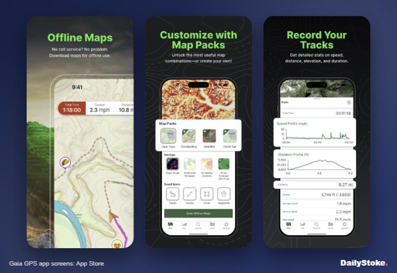
Gaia GPS is a map-and-GPS app built for terrain. You plan a route on the web or phone, choose from a menu of base maps and overlays, download the area for offline use, then record your track as you go. It also covers off-road driving and skiing, with resort information from OnTheSnow.
Where it shines:
- A ski tour in the Wasatch or the Valais. Turn on slope-angle shading to see which slopes sit in avalanche-prone angles, then layer it over a topo map before you set out. It is no substitute for an avalanche forecast or training, but it is a powerful planning aid.
- A week on the John Muir Trail. Download National Geographic Trails Illustrated maps and satellite imagery for the whole route, then navigate without signal.
- A drive into US public lands. Land-ownership overlays show where you can legally camp.
Gaia GPS price: free versus Premium
The free level covers waypoints, trip recording, GPS position, photos, track backup to gaiagps.com and printing Gaia Topo maps. Other map sources are locked, and downloaded maps become unavailable without a membership.
Premium adds, according to Gaia’s help centre and App Store listing:
- The full catalogue of more than 300 maps and overlays, including France IGN, SwissTopo and US hunting and land maps
- Offline downloads, including layered maps
- Overlays such as hill-shading, contour lines and slope angle
- Printing of all maps from the website
Premium with Outside+ adds Outside’s digital magazines and archives, Outside Learn courses, Trailforks route data for mountain bikers and Outside Watch video.
| Plan | US App Store | German App Store |
|---|---|---|
| Free | Free | Free |
| Premium, yearly | $59.90 | €59.90 |
| Premium with Outside+, yearly | $89.90 | €99.90 |
Both paid tiers are listed with a free trial on the App Store. Gaia’s help centre warns that the trial converts automatically into an annually renewing paid subscription, so cancel before the conversion date if you do not want to pay.
Gaia is priced in dollars and euros; we could not confirm a UK sterling price at the time of writing. Long-time users noticed a big rise in 2024: in an Expedition Portal forum thread from May 2024, members reported renewal notices taking Premium from about $40 to $59.90 a year.
What we liked
The layer menu. No other app in this group offers so many maps to stack and compare. Switching between a topo map and satellite imagery tells you whether that “path” is a trail or a dry streambed.
Slope angle. For ski touring and winter walking this is the standout feature, and the main reason it fills the gap left by FATMAP, which Strava closed on 1 October 2024.
Offline that you control. Download exactly the area and layers you need, at the zoom levels you choose.
Watch and car. Apple Watch can start and stop recordings, and CarPlay shows maps, routes and waypoints on the dashboard.
Strong in the Alps. IGN and SwissTopo maps make it a credible choice for the Alps, where official mapping is superb.
What we did not like
No current OS mapping. Users in Gaia’s own community forum say Ordnance Survey maps were dropped and have asked for them for years. One workaround is to add historical OS sheets from the National Library of Scotland as custom maps, but these are decades old.
The price. At about $60 a year it costs more than OS Maps or AllTrails+, and the 2024 rise annoyed loyal users.
Learning curve. Layers, folders and tracks take time to master. Casual walkers may find it overwhelming.
Thin route discovery. It does not compete with AllTrails’ reviews or Komoot’s planner for finding a walk.
American focus. Much of the catalogue, from public-land overlays to hunting units, is US-only.
How Gaia GPS compares
| Gaia GPS | OS Maps | AllTrails | |
|---|---|---|---|
| Paid from | $59.90 a year | £35.99 a year | £35.99 a year |
| Best for | Backcountry and ski touring | British hills | Finding walks |
| OS 1:25,000 | No | Yes | No |
| Slope angle | Yes, Premium | No | No |
Gaia GPS vs OS Maps. In Britain, OS Maps wins on mapping and price. Gaia wins abroad and in winter terrain. Read our OS Maps review.
Gaia GPS vs AllTrails. AllTrails is for choosing a walk and following it; Gaia is for planning your own way across complex ground. Our AllTrails review explains its strengths.
Gaia GPS vs Organic Maps. If you just need a free offline map with paths and contours, Organic Maps costs nothing. Gaia adds layers, satellite imagery and slope angle.
Who should buy Gaia GPS
Buy it if you hike, ski tour or drive in the American West, Canada or the Alps and want serious offline mapping. Ski tourers who lost FATMAP should try it first. Skip it if you mostly walk in Britain: OS Maps or Outdooractive Pro will serve you better for less.
Gaia GPS FAQs
Is Gaia GPS free?
Yes, there is a free level with trip recording, waypoints and the Gaia Topo map. Offline downloads and the full map catalogue need Premium.
How much is Gaia GPS Premium?
$59.90 a year on the US App Store and €59.90 on the German App Store. Premium with Outside+ costs $89.90 a year in the US.
Does Gaia GPS have Ordnance Survey maps?
Not current 1:25,000 OS maps. You can add historical OS sheets from the National Library of Scotland as custom maps, but for up-to-date British mapping use OS Maps or Outdooractive.
Is Gaia GPS good for ski touring?
Yes. Its slope-angle overlay is useful for planning, though it never replaces an avalanche forecast, training and proper kit.
Does Gaia GPS work with Apple Watch and CarPlay?
Yes. The App Store listing supports Apple Watch on watchOS 7 or later and shows maps, routes and waypoints on CarPlay.
More on DailyStoke
Best hiking apps compared · Best offline map apps · OpenSnow review · OS Maps review · Travel apps, reviewed